Tuesday, 3 April 2012

Three times the view

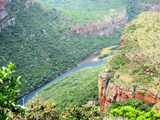
At the northern end of the mighty Drakensberg Range, and standing sentry at one end of the Blyde River Canyon is the most famous - and photographed - attraction in the region, the Three Rondavels.

The harder rock layers on top eroded slower than the underlying softer layers of stone, which resulted in rock formations which resemble African rondavels.
A rondavel (from the Afrikaans word 'rondawel') is a westernised version of the African-style hut.
The rondavel is usually round or oval in shape and is traditionally made with materials that can be locally found in raw form.

The views here is spectacular and small circular walk takes you to all the best spots allowing you to get a good look at not only the rondawels but also the countryside as a whole.


As we got back into the car and headed towards our accommodation for the night we could not help smiling. This truly is the Garden of Eden;  the cradle of man kind.

Tuesday, 27 March 2012

Bourke's Luck

As we were driving along the Panorama route I could not help feeling pride in being a South African. We are so blessed to be living in such a diverse and beautifull country. We need to protect what is ours. Keep our rivers free of pollution, protect our indegenous flora against foreign murderous plants and protect our wildlife and especially rhino's against evil poachers!
Bourke's Luck Potholes, were named after prospector Tom Bourke who discovered alluvial gold in the area during the late 1880's Their formation is a natural phenomenon created by the swirling river water.

Located approximately 35 km north of the town of Graskop, the site has grown in popularity as one of the province's best tourist destinations. The potholes which lie at the confluence of the Treur and Blyde rivers, were formed millions of years ago by the swirling of sand and pebbles, which resulted in the carving of the potholes into the underlying riverbed.


The site is managed by the Mpumalanga Parks Board and a nominal entrance fee applies. A 700 m long circular path, with a number of pedestrian bridges over the river direct visitors towards the best vantage points.
The Potholes are really impressive and you can spend hours walking around and admiring the intricate and beautifull rock formations. The paths and lookout points are well looked after and very clean. The toilets were clean and well stocked with toiletpaper. (always important) Just like all the other tourist sites in the area the parking lot is dotted with stalls selling locan handicrafts.

Bourke's Luck should definatelly be a must see on every tourist itenerary. :)

Sunday, 11 March 2012

Where Angels Tread

Today is a big day with a lot of sightseeing on our itinerary. From Pilgrim's Rest we headed back up the mountain towards Graskop.

Our first stop was The Pinnacle. An impressive finger rock in the centre of a deep ravine complete with waterfall. (Yes another one!)  On this particular day the fog was pretty dense which made for an ominous looking Pinnacle.

On a clear day the view is quite different...

There are various lookout points allowing you to see the 'big rock' from different angles. A short hike will take you around to the opposite cliff face for a nice view of the before mentioned waterfall.


Before we could reach the other side though we had to cross the small river. Careful now, you do not want to slip and and tumble over the edge...


The next stop along our route is known as God's Window. From the parking area it is a short but steep hike to 'The Garden of Eden'. Once you pass through the 'Garden' the vegetation opens up offering you a spectacular view of the Canyon.

Luckily for the not so fit there are many other vantage points along the way...


All of the pictures above was taken by me on previous visits. On this day when Stiaan and I visited all we could see was this...

At least we managed to see a 'Love Leaf" :)

Next stop Burke's Luck!

Saturday, 10 March 2012

Pilgrims Rest

Pilgrim"s Rest is a small town in the Mpumalanga province of South Africa which has been declared a national monument. After it was officially declared a gold field in September 1873, it suddenly grew to 1500 inhabitants searching for alluvial gold. It was a real boom town and is said to have had street lights before London England. Quite an accomplishment for a small mining village somewhere near the end of the earth.

Mining was closed down in 1971 and the village sold to the government as a national museum. The town's original architecture remains largely unchanged since then.


All of the original buildings have been beautifully restored and turned into museums or curio shops. It is a real treat walking here. Surrounded by history. The Garage houses some old cars and motorcycles. I can not believe that these made it up the mountain we just came down!
Every visitor to the town is encouraged to have a drink at the Royal Hotel Bar. We simply had to follow tradition.
After more than a couple of drinks in the bar and an absolutely delicious lunch in the Hotel Restaurant we decided to spend the night in the Royal Hotel. Besides it was still raining outside and we did not feel like pitching our tent in the rain AGAIN!

Walking around after breakfast the following morning we came across the old Methodist Church where services are held every Sunday

Strolling though the old Graveyard we came across the old Robbers Grave. Emblazoned simply with a cross and the large type words of Robbers Grave. It is as the name suggests the grave of a robber who was convicted of stealing a tent from one of the miners. A tent represented a 'home' so was the most valuable of any of the individuals belongings. Stealing this tent was a most grievous crime and the punishment was meted out in the extreme. The young man was subsequently banished from the town.  A few days after his trial, the thief was spotted on the hill overlooking the town. Now known as Cemetery Hill, this is where the robber was shot, killed and buried. His grave was placed north-south to brand him a thief forever. All the other graves in the cemetery are oriented east-west.